Salam Bro's i have a suggestion i saw different Route maps Marked by Google Earth scatted in different Threads why not we share route maps on a single thread for reference.It will help a lot people in planing there tourIndex:1) Pir Chinasi To Pir Hassimar 2) Karomber Lake 3) Rush Lake 4) Rakaposhi BC
Here we go the first oneCourtesy:One & Only aesiege:Trek Name:Pir Chinasi TO Pir HassimarRegion: Azad Kashmir
Trek Name: Karomber LakeRegion: Wakhan CorridorCourtesy: Dashtnavard Blog[h=2][/h]
All members are requested plz update this thread
wonderful
i dont have any gfoogle maps but will share any useful data here soon IA
Let me know what u guys want from my Google Earth version of North of Pakistan
who cud resist such a map...............
I think Latitude/Longitude coordinates of point of interests like Hotels, Trek Data files with a good update speed could be interesting. Sharing the files so that others could follow the Guru Footsteps as it happened in reality not virtual . OVL files if i am not wrong is the format for google earth? But drawing maps on the application is no big deal. A planned route from major cities etc would be helpful with realtime data
Following are the few maps taken from khyber.org. Good maps with detailed Legends.
Map are old but details provided in them is very informative.
nice input
Another Karomber Lake Map
Rush Lake:
Concordia-GGLA
Dowarian To Ratti Gali Lake:Distance : 17 KMAscend/ Descend: 7,116 ft /459 ftMin Alt/ Max Alt: 5410 ft / 12073 ft
zabardast maps gemini85
Thx sir
Besal To Doodipat Sar:Distance : 15 KMAscend/ Descend: 2,243 ft /194 ftMin Alt/ Max Alt: 10,554 ft / 12,805 ft
Kel To Arang Kel:Distance : 3.2 KMAscend/ Descend: 1,322 ft /449 ftMin Alt/ Max Alt: 6,565 ft / 7,782 ft
Chitta Katha Lake Trek:Distance : 8.3 KMAscend/ Descend: 5,384 ft /1,522 ftMin Alt/ Max Alt: 9,232ft / 13,445 ft
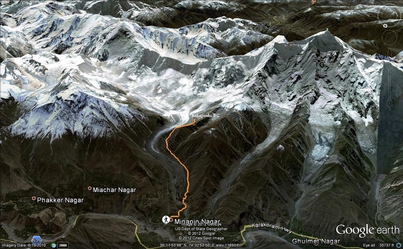
Minapin ToThagaphri (Rakaposhi BC)Distance : 9.5 KMAscend/ Descend: 4,774 ft /3,08 ftMin Alt/ Max Alt: 6,660 ft / 11,401 ft